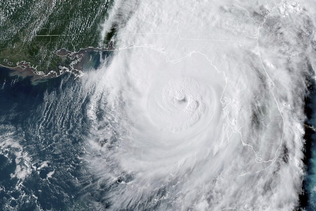
Hurricane Milton is expected to hit landfall Wednesday evening in Florida, and it’s expected to pack a wallop. It’s hit a Category 5 at some points and is currently at Cat 3—still extremely dangerous.
The storm comes just days after Hurricane Helene battered the southeast United States, leaving a path of destruction and death that the region is still trying to recover from.
Most people would get as far away as they could from Milton, but not pilots for the National Oceanic and Atmospheric Administration (NOAA) Hurricane Hunters squad—they fly directly into storms to collect atmospheric data and help track where the hurricane will hit.
Watch these guys take a wild ride on a WP-3D Orion called “Miss Piggy” as they hit some serious bumps:
Bumpy ride into Hurricane #Milton on @NOAA WP-3D Orion #NOAA43 “Miss Piggy” to collect data to help improve the forecast and support hurricane research.
Visit https://t.co/3phpgKNx0q for the latest forecasts and advisories
Visit https://t.co/UoRa967zK0 for information that you… pic.twitter.com/ezmXu2Zqta— NOAA Aircraft Operations Center (@NOAA_HurrHunter) October 8, 2024
In this next video, first an amazing photo from space shows us the massive size of the storm.
Then, NOAA Hurricane Hunters lead pilot Lieutenant Commander Josh Rannenberg, who flew through the eye of the storm, describes how it’s the worst he’s ever seen. “That is a terrifying shape,” Rannenberg said as he looked out the aircraft. “I am scared for everyone in the Tampa Bay area.”
“This is going to change some lives, y’all. Change some lives.”
Just released: Lieutenant Commander Josh Rannenberg, NOAA hurricane hunters lead pilot discusses his flight thru the eye of Hurricane Milton 😎👊👊👊🇺🇸 pic.twitter.com/WtEdjfVXpG
— 𝐉𝐎𝐇𝐍 𝐖𝐈𝐂𝐊 𝕏ʰⁱᵗᵐᵃⁿ 🔫 (@imUrB00gieman) October 9, 2024
Rannenberg continued:
This has been probably the worst storm I’ve ever flown through, and it’s kind of hard to watch. I’ve been seeing some of the footage as it approaches Florida. Especially now that that’s my home, it’s difficult to see after having flown in it.
Fox Host Shannon Bream asked him to compare it to other storms he’s flown through.
This one was aggressive… It was just a tough mission from start to finish today. We took off around 3:00 a.m. out of Mobile, Alabama, and flew into the storm… We flew inside… that weather was rough and it was a, it was just a grind for us. A lot of the storms we can find some safe space, loiter for a minute and kind of get our bearings.
But this storm? It was an animal from start to finish.
He described flying through the eye:
We’re inside the eye of the storm, we penetrate the eye of the storm from the side. We’re usually at 8,000 feet, and to give you a frame of reference, the top of the storm is 55,000 feet. So we’re going right through all of it. We go through the wind, the hail, the turbulence. And it’s, it’s tough to do sometimes…
Bream wondered how he was feeling, considering that he lives in Florida:
Like I said and that’s the internal conflict right now is flying these missions. I have a great sense of purpose and pride and I love it. I love every minute… But watching, seeing this storm develop from a tropical storm to a Category 5 hurricane and now making landfall near my home, it ratchets up the stress a little bit, and it brings a lot of anxiety, and that’s kind of the internal conflict I’m feeling.
It’s gripping footage, but it also reminds us of the danger Florida residents face as the hurricane gets ever closer to landfall. We pray for all those affected and will keep you updated on developments as they occur.
As conditions deteriorate thru this evening determine where your shelter within shelter will be. Your tornado threat will be increasing. If you are near the center as #Milton makes landfall, you may receive an Extreme Wind Warning!
Follow these tips to find that location👇#FLwx pic.twitter.com/PfqZxw6lWF
— NWS Tampa Bay (@NWSTampaBay) October 9, 2024
